Category:3 Creating Virtual Field trips: Step by step process
From V-Global Wiki
...
Contents |
General participatory steps
For the development of every participatory project, from the participatory design of a public space to the co-production of a cultural campaign or the co-creation of a VFT, we follow these general steps:
- Definition of the goals, action plan, and the target groups of the project
- Data collection
- Collective brainstorming
- Realization of the participatory project's main actions (in our case, the creation of a Virtual Field Trip)
- Presentation to the group/community
Athens and Hamburg Virtual Field Trips (VFT)
The project partners created Virtual Field Trips in 2 different study fields by developing and implementing 2 different participatory step by step methodologies:
- Athens | collaborative work based on mapping | data collection without predefined forms
- Hamburg | collaborative work based on image and content creation | data collection with predefined forms and thematics
The Athens Virtual Field Trips: Step by step guide
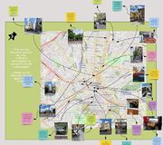
We organized a collective mapping workshop to collect data and co-create stories. After walking around the city center, the working team implemented a collaborative mapping workshop with the help of Miro (see the tools proposed).
Steps/How to do:
1. Before the trip: Define the goal and co-design the field trip
Recruit the participants and discuss:
- Why are you doing this? What is the collective goal of the field trip? (e.g., a virtual field trip, a public space study for future intervention, or a public space narration)
- Where is the field trip taking place? What is the study area (e.g., a suburb, the city center, a specific neighborhood, a route, a public space, or a plot)? What is the scale (e.g., local level, neighborhood level, etc.)?
- Who are the participants? What is their level of expertise and their interests? What is their connection to the field and area of study?
- What data will you collect, and in which format?
You can run this step using Miro templates for brainstorming (idea trees, tables, or voting sessions).
2. During the walking trip: Data and experience collection Organize the field trip, study the area from Google Maps, and explore secondary data. Design the routes and the points of interest to visit, get some water and snacks, charge your smartphone and camera, and start walking! Don’t forget to discuss and agree with the participants about the form of data you will collect and how you want to save and store all the information (e.g., images, videos, notes, recordings).
3. After the walking trip: Co-design your VFT
- Co-design stories and co-reflect on the narrative: Meet with the participants online or physically. You can work individually or in groups according to the number of participants.
- Create an inclusive and cozy atmosphere with an icebreaker game: You can find many icebreaker activities in Miro templates or you can design your own. A straightforward introductory game invites the participants to write their names and field of work, along with a short sentence or an emoji that reflects their mood.
- Discuss the data and pin them on a map or a plan: This is the most important step of the collective process. Define how the participants will upload and pin their data on the map. For example: Ask the participants to choose three favorite photographs, sketches, or notes gathered during the field trip; pin those selected items on a map; and write a sticky note explaining why they are important/interesting.
- You can see an example in the following link [1]
- Chose data to include in the story: You can run a voting session in Miro. Invite the participants to decide what their favorite input data are. This step helps the group organize their thoughts and allows them to conclude ideas.
- Create a collective narrative: Let the participants discuss what they have collected, build consensus on the narration, or identify their perspective on public space. For example, their narrative could be “The daily life in the city center” or “Global change and the city”.
- Present your work to the whole team: Allocate a few minutes at the end of the workshop for each team to present their story Exchange ideas about the city, the public space, and the narratives. Empower reflection and promote discussion.
- Here you can find all the VFTs created in Athens, by the partners [[2]]
The Hamburg Virtual Field Trips: Step by step guide
We designed different thematic routes in the city and a predefined form for data collection. After the walking trips, we implemented a collaborative workshop based on image analysis and content creation in order to create virtual stories. For this exercise we used Padlet.
Steps/How to do:
1. Before the trip: Define the goal and co-design the field trip
- Create different thematic walking routes in the city. (e.g., gentrification, urban green, urban design)
- Create predefined forms for the participants to fill in, for data collection. For example see the link [3]
2. During the walking trip: Data and experience collection
- Divide people into different thematic groups regarding their interests or fields of work.
- Each group walks around the city and collects data. It is important to clarify each thematic's context and the data participants should collect and import in the predefined forms. (for example, if they will record buildings, photos of points of interest, etc.)
- Feel free to create any material that could be helpful for the participants, such as maps of the walking tour, descriptions of the important landmarks they will meet on their way, and explanatory material regarding the subject of study.
3. After the walking trip: Co-design your VFT Divide people into groups. Each group will create one VFT by performing the following exercise. The concept of the exercise is to find a collective narrative for a VFT by creating content through images. People share their ideas and conceptions of the city by connecting words with pictures. For this exercise, you will need the following:
- Three categories of words (SOCIETY-ENVIRONMENT-ECONOMY. These categories are important as every space and spatial phenomenon can be explained through these three critical axes)
- Words for each category. (For example, ECONOMY: Gentrification, profit. SOCIETY: segregation, culture, community)
- To ask participants to bring 1-3 photos they collected during the field trip.
During the exercise:
- Each participant uploads 1-3 photos from their walking trip. Finally, a library of photos is created in the group.
- Everyone tags each photo of the library with a word coming from one of the categories (SOCIETY-ECONOMY-ENVIRONMENT) regarding its content. The point is to tag a word that describes the photo better.
- Vote for the most representative word for each photo.
- Collect and discuss all the words: Count how many words come from each category and brainstorm how vital these categories could be for your collective narrative.
- Create stories from the photos and content of their narrative
- Find a title and keywords for the VFT
- Present their work to the whole team
- You can see an example in the following link [[4]]
This category currently contains no pages or media.


